 EMODnet Product Catalogue
habitat, biotope, sea, sea bed, sediment, classification
Type of resources
Available actions
Topics
Keywords
Contact for the resource
Provided by
Years
Formats
Representation types
Update frequencies
status
Scale 1:
Resolution
-
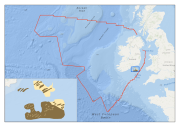
Multibeam echosounder data and seabed sampling data acquired during the INFOMAR national seabed mapping programme were the primary sources of data used in the generation of this habitat map for the Inshore Fisheries section of Bord Iascaigh Mhara. The original sediment classes assigned to the data were translated to the EUNIS habitat classification system as part of the MESH Atlantic project.
-
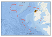
Multibeam echosounder data and seabed sampling data acquired during the INSS and INFOMAR national seabed mapping programmes were the primary sources of data used in the generation of this habitat map. The original sediment classes assigned to the data were translated to the EUNIS habitat classification system as part of the MESH Atlantic project.
-
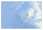
Multibeam echosounder data and seabed sampling data acquired during the INSS and INFOMAR national seabed mapping programmes were the primary sources of data used in the generation of this habitat map. The original sediment classes assigned to the data were translated to the EUNIS habitat classification system as part of the MESH Atlantic project.